Marine Gazetteer
Dealing with different names of geographic features or entities, VLIZ developed a standard, relational list of geographic names, coupled with information and maps of the geographic location of these features. The purpose of the gazetteer is to improve access and clarity of the different geographic, mainly marine names such as seas, sandbanks, ridges, bays or even standard sampling stations used in marine research. The geographic cover is global; however the gazetteer is focused on the Belgian Continental Shelf, the Scheldt Estuary and the Southern Bight of the North Sea.
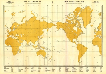
The higher classification of oceans and seas in the Marine Gazetteer
is based on the chart 'Limits of Oceans and Seas', published by the IHO
Structure & technology
All geographic objects of the Marine Regions database have a unique ID, called the MRGID (Marine Regions Geographic Identifier). The different geographic objects are determined by a placetype and coordinates. While the coordinates are represented as different vector data types being a point, a line or a polygon, a placetype provides contextual information to the geographic objects, for example a sea, a bay, a ridge, a sandbank or an undersea trench. Not only physical placetypes are considered, but also administrative placetypes, like countries, EEZ's, fishing zones or territorial seas can be stored in the database. The actual names of the geographic objects are stored as a different entity, allowing thus multiple naming for one geographic object (ie dealing with different languages). It is possible to define different relations between the geographic objects (part of, adjacent to, streams through or flows out). Such a structure allows the user to group joint geographic units and to create a hierarchical classification of different places. You can view the database schema here
If a point, a line or a polygon is available for a geographic object of Marine Regions, a dynamic map will appear. The geographic interface is based on the OpenLayers technology. All shapes are uploaded to a local GeoServer installation, allowing serving the geographic objects as different WMS and WFS services.
Applications
Not only is the Marine gazetteer valuable as a search tool on its own, but lots of applications can be derived from it, such as linking different datasets, species distributions or sampling campaigns with geographic entities from the gazetteer. Each GeoObject can have a certain context. This allows us to query a defined group of geographic entities. For example to query all the geographic entities of the Belgian Continental shelf linked to a project that is carrying out research on these geographic places. Applications of the Marine gazetteer so far are:
- MARBEF Data System: The gazetteer integrates all different placenames used in the data system of the Marine Biodiversity and Ecosystem Functioning EU Network of Excellence.
- Scheldemonitor:The gazetteer integrates all different placenames used in the data system developed for all information related to the Scheldt river and estuary
- World Register of Marine Species: Distribution records of marine species are linked with the geographic entities of Marine Regions
- World Porifera Database: The localities of the holotypes of the world Porifera database are linked with the Exclusive Economic Zones (EEZ's) of the VLIMAR gazetteer.
- World database of Cumacea: Biogeographic data of this database of marine Cumacea are linked with the VLIMAR gazetteer.

