User testimonials
Loading video...
About Marine Regions
Marine Regions is a standard list of marine georeferenced place names and areas. It integrates and serves geographic information from the VLIMAR Gazetteer and the MARBOUND database and proposes a standard of marine georeferenced locations, boundaries and regions.Read more...
Statistics
64,646 marine georeferenced places79,610 marine place names
39,974 polygons of geographic places
12 marine geographic regional/global classifications
Maritime Boundaries (EEZ) of the world
News

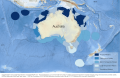
IMCRA v4.0 Provincial Bioregions added to Marine Regions
Added on: 2026-05-06 15:36:06 by Lonneville, Britt
Marine Regions has included the IMCRA v4.0 Provincial Bioregions of Australia in its database. ...
Annual update of GEBCO and ACUF gazetteers completed
Added on: 2025-10-30 15:32:28 by Lonneville, Britt
Marine Regions integrates the latest additions from GEBCO and ACUF into its global gazetteer ...
Updates of four Maritime Boundaries derived products
Added on: 2024-10-11 14:38:47 by Lonneville, Britt
Marine Regions launches new versions for the High Seas, Extended Continental Shelves, Intersection of Exclusive Economic Zones and IHO Sea Areas and Union of Exclusive Economic Zones and Land Areas ...
Marine Regions hosts introductory meeting for renewed Editorial Community
Added on: 2024-09-18 14:22:53 by Lonneville, Britt
Renewed Editorial Community meets as part of Ocean Decade Project Action ...
Explore Marine Regions in R with mregions2
Added on: 2024-06-25 16:37:14 by Fernandez, Salvador
The package provides programmatic access to the gazetteer and data products ...[Add] [Older news... ]

Picture: Karl Van Ginderdeuren ©

