Marine Regions web services
Marine Regions provides several web services which allow the user to have direct access to the geographic data, maps and metadata from a GIS desktop or for online applications.
OGC web services

 Web Map Service (data visualisation)
The Web Map Service standard (WMS) provides a simple HTTP interface for requesting geo-registered map images from one or more distributed geospatial databases. A WMS request defines the geographic layer(s) and area of interest to be processed. The response to the request is one or more geo-registered map images (returned as JPEG, PNG, etc) that can be displayed in a Geographic Information System (GIS) or in your own web application (OpenLayers, Leaflet,...). The WMS supports the GetCapabilities, GetMap and GetFeatureInfo operations as defined in the Open Geospatial Consortium (OGC) WMS standard.
The Marine Regions WMS service is accessible from the following endpoint:
https://geo.vliz.be/geoserver/MarineRegions/wms
WMS metadata (GetCapabilities)
The mandatory GetCapabilities operation allows WMS clients to retrieve service metadata from a server. The response to a GetCapabilities request shall be an XML document containing metadata of the service (proposed layers, associated projections, author ...).
The standard to construct a WMS GetCapabilities request, depending on the version:
https://geo.vliz.be/geoserver/MarineRegions/wms?SERVICE=WMS&VERSION=X.X.X&REQUEST=GetCapabilities
Possible values for X.X.X:
- 1.1.1
- 1.3.0
An example of a GetCapabilities request addressed to the Marine Regions view service:
https://geo.vliz.be/geoserver/MarineRegions/wms?request=getCapabilities
Map visualisation (GetMap)
Using the information given in the GetCapabilities request, the GetMap request returns an image of the requested data layer selected from all the available layers as defined in the XML document. The elements such as the data layer, region, projection, size of the returned image, image format, etc. are defined in the form of arguments.
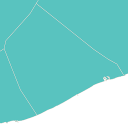
Example of a GetMap request that returns an image of the Exclusive Economic Zone of Belgium:
https://geo.vliz.be/geoserver/MarineRegions/wms?SERVICE=WMS&VERSION=1.1.1&REQUEST=GetMap&LAYERS=eez&STYLES=&TRANSPARENT=TRUE&SRS=EPSG:4326&BBOX=2.2,51,3.4,51.9&WIDTH=256&HEIGHT=256&FORMAT=image/png
returns:
Using Web Map Services in GIS/programming languages
In order to study the provided data in more detail or add them as background images in maps, they can be loaded into GIS software or invoked using various programming languages. How to do this on some of the most common platforms is explained in the manuals below:
- Loading a WMS layer in QGIS
- Loading a WMS layer in ArcGIS Pro
- Loading a WMS layer in R
- Loading a WMS layer in Python
Web Feature Service (data download)
WFS defines a standard for exchanging vector data by querying both the data structure and the source data. The basic operations are GetCapabilities, DescribeFeatureType, and GetFeature. WFS supports a variety of WFS output formats (e.g. GML, shapefile, JSON, GeoJSON, CSV,...). The full list of output formats supported can be found by performing a WFS GetCapabilities request.
The Marine Regions WFS service is accessible from the following endpoint:
https://geo.vliz.be/geoserver/MarineRegions/wfs
WFS metadata (GetCapabilities)
A GetCapabilities request generates a metadata document (xml) describing a WFS service provided by server as well as valid WFS operations and parameters.
The standard to construct a WFS GetCapabilities request, depending on the version:
https://geo.vliz.be/geoserver/MarineRegions/wfs?SERVICE=WFS&VERSION=X.X.X&REQUEST=GetCapabilities
Possible values for X.X.X:
- 1.0.0
- 1.1.0
- 2.0.0
An example of a GetCapabilities request addressed to the Marine Regions download service:
https://geo.vliz.be/geoserver/MarineRegions/wfs?Request=getCapabilities
Feature type information (DescribeFeatureType)
A DescribeFeatureType request returns a description of feature types supported by a WFS service.
An example of a Marine Regions DescribeFeature request:
Download data (GetFeature)
A GetFeature request returns a selection of features from a data source including geometry and attribute values.
Building a WFS query to get dataFor composing your own query, you need to combine different parts:
- the base url
- the requested layer
- filtering options (optional)
- the output format
1. The base URL
The base link for performing a WFS request to Marine Regions is:
https://geo.vliz.be/geoserver/MarineRegions/wfs?service=WFS&version=1.0.0&request=GetFeature&
2. The requested layer
All available layers in the Marine Regions download service can be requested using a getCapabilities request.
The syntax for specifying a layer is:
typeName=_insert_layername_
3. Filtering options
If you only want to download specific records of a layer, you can add a filter to the WFS request. This filter can take into account (among others) geometry and attribute values. Available attributes can be discovered using a DescribeFeatureType request.
This example will return a shapefile of the Belgian Exclusive Economic Zone (MRGID 3293).
https://geo.vliz.be/geoserver/MarineRegions/wfs?service=WFS&version=1.0.0&request=GetFeature&typeNames=eez&cql_filter=mrgid=3293&outputFormat=SHAPE-ZIP
A more detailed description of using CQL filters can be found in the GeoServer manual.
4. The output format
Marine Regions data are available in a number of output formats, which are indicated at the end of the WFS request as:
outputFormat=_insert_output_format_
- csv
- json
- shapefile
- kml
For other output formats, see the GetCapabilities request which returns the complete list of output formats available for each type of WFS request: https://geo.vliz.be/geoserver/MarineRegions/wfs?service=WFS&version=1.0.0&request=GetCapabilities
Using Web Feature Services in GIS/programming languages
In order to study the provided data in more detail or perform further spatial analyses on them, they can be loaded into GIS software or invoked using various programming languages. How to do this on some of the most common platforms is explained in the manuals below:
- Loading a WFS layer in QGIS
- Loading a WFS layer in ArcGIS Pro
- Loading a WFS layer in R
- Loading a WFS layer in Python
Catalogue Service for the Web (metadata)
The Marine Regions catalogue offers the ability to search its collection of metadata for data, services and related information objects. The data catalogue offers a CSW endpoint to other client applications to connect to the service and query the metadata held in the catalogue.
http://geonetwork.vliz.be/geonetwork/srv/eng/csw?request=GetCapabilities&service=CSW
How to harvest this CSW service into GeoNetwork is explained here.

